BULLETIN 245
TORONTO IN PICTURES AND PRINT: FROM THE TOWN OF YORK TO THE GTA
ATLASES & MAPS – 257-314
ATLASES
257. CITY OF TORONTO. PLANNING AND DEVELOPMENT DEPARTMENT. Toronto Planning Atlas Computer Drawn Maps Of Planning Indicators For Metropolitan Toronto… Stephen G. McLaughlin, Commissioner August 1980. pp. [4], 107. many maps (some colour), diagrams & few b/w illus. spiral bound wrs. (rubberstamp name to title & outer margins of few leaves). Toronto: 1980. $300
“The City of Toronto Planning and Development Department gets many requests for maps showing key features of Toronto’s people, households and jobs… To meet their needs, the Department has developed CIYTMAP, its computer mapping package…” (Introduction)
258. CITY OF TORONTO. WORKS & EMERGENCY SERVICES SURVEY & MAPPING SERVICES. Property Data Maps [Cover Title]. [ff. 3, index map, parks index, streets index]. 172 maps of 176. lacking 4 maps (50F23, 51F13, 51F21, 51F22). cloth with metal spine & posts measuring 26” x 24 ½” (66 x 62 cm) (covers bit scuffed). Toronto: 1999. $2,800
Revised to January 1999, the property index maps provide detailed information on parks, streets, railroads, buildings, roads, heritage properties &c. The maps cover the City of Toronto, including North York, East York, York, and Etobicoke.
 No. 259
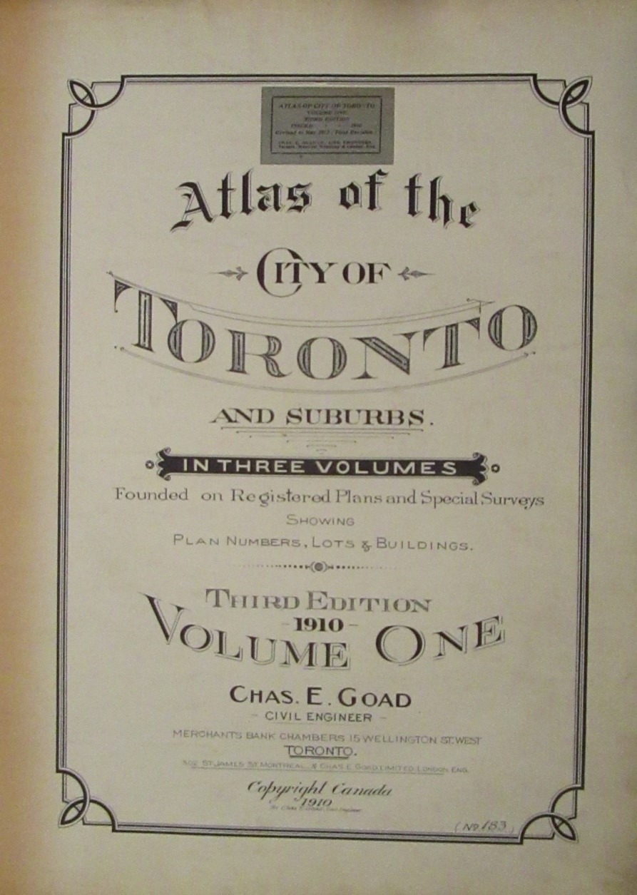
259. GOAD, Cha[rles] E. [1848-1910]. Atlas of the City of Toronto and Vicinity From Special Survey Founded On Registered Plans And Showing All Buildings And Lot Numbers Third Edition - 1910. 3 Volumes.folio. [pp. 9; 5; 3]titles & street & registered plan indexes. 3 single-page & 119 double-page coloured maps numbered 1, 1[bis], 2-84, 101-133.some mounted correction slips. later half pigskin over original cloth sides (short splits in upper joints of Vol. I, remains of tabs on maps). Toronto: 1910-[12-13]. $16,000
Third Edition, first revision to May 1912 (Volume I), first revision to October 1923 (Volume III). The first edition, published in 1884, contained 40 maps, and the second, published in 1890, contained 50 maps. The third was greatly expanded to 2-3 single-page & 114-119 double-page maps in 1910. The maps in this atlas were revised to incorporate new information by means of mounted correction slips or by reprinting in 1912 and 1913.
"What "Goad is to Canada, "Sanborn" is to the United States, a quasi-monopoly on municipal mapping for a century, and a companion to the insurance industry." (Maps & Data Library, University of Toronto website) Established in Montreal in 1875, the Charles E. Goad Company had by 1910 created fire insurance plans for more than 1300 Canadian communities. These street atlases serve as important source materials for the progress of urban development, containing detailed maps showing and naming streets, lots, homes, businesses, churches, schools, parks, government buildings, hotels, banks, and stores. Plans were produced primarily at a uniform scale of fifty feet to one inch and typically colour-coded to denote building construction materials: pink indicating brick, blue indicating stone, and yellow illustrating frame construction.
See Gentilcore & Head, Ontario’s History in Maps, pp. 264-65.
260. GUIDAL, A[lbert] E. 1917 Commercial Directory Atlas Of The Townships Of Western Ontario …Toronto District… 5 sections with divisional titles: 1917 Commercial Directory Atlas Of The Townships Of Ontario County (Province of Ontario)... oblong folio. title + 11 maps (10 in colour). [WITH:] 1917 Commercial Directory Atlas Of York County… title + 10 coloured lithographed maps. [WITH:] 1917 Commercial Directory Atlas Of Halton County… title + 6 lithographed maps (4 colour, 1 folding). [WITH:] 1917 Commercial Directory Atlas Of Peel County… title + 6 coloured lithographed maps (5 in colour). [WITH:] 1917 Commercial Directory Atlas Of Wellington County… title + 12 lithographed maps (11 in colour). original cloth binder, cloth ties (edgewear & a few small losses of cloth on sides, the Western Ontario key map partly defective & in tatters with cellotape repairs & stains, tears to edges of some maps - occasionally entering image but with no loss, tears in title with small section detached but present, some light soiling). Toronto: Map and Advertising Company Limited, [1917]. $4,000
This is the Toronto District section of the 1917 Commercial Directory Atlas Of The Townships of Western Ontario (4 other sections were published). The atlas includesa key map of Western Ontario, 6 county maps of Ontario County, York County, Halton County (2 - 1 folding, only 1 called for), Peel County, and Wellington County, and 38 township maps of Pickering, Whitby & East Whitby, Uxbridge, Reach, Brock, Scott, Thorah, Mara, Rama, Scugog (not called for on divisional title), York, Scarboro, Etobicoke, Markham & Whitchurch, Vaughan, King, East Gwillimbury, North Guillimbury, Georgina, Nelson, Trafalgar, Nassagaweya, Esquesing, Toronto, Chinguacousy, Caledon, Toronto Gore, Albion, Puslinch, Guelph, Pilkington & Nichol, Erin, Arthur, Minto, Eramosa, Maryborough, Garafraxa West, and West-Luther (not called for on divisional title). Each township map shows landowners' names, roads, towns, villages, lakes, streams, and railways. The Canadian National Union catalogue cites only the Toronto Public Library copy, which calls for 40 township maps. It is listed in Worldcat but no locations are given. Rare.
261. ROBERTS & REEVES. [Toronto] Down Town Property Chart. large oblong folio. 16 maps, all linen-backed except for key-plan. 9 smaller leaves of text. original (?) bds., leather label (binding worn with some damage but sound, key-plan with long tear - no loss & tattered edges, other maps linen-backed & with edge-wear). [Toronto: c1930]. $4,000
The maps show properties with landowners, land and building valuations, and lot sizes in downtown Toronto bounded by Front, Victoria, Queen, & Simcoe Streets, excluding Yonge St. strip. Rare: we have only been able to locate at the University of Toronto a photoreproduction lacking one map, based on the original at the Metropolitan Toronto Library. The original however is not recorded in the Metropolitan Toronto Library database.
262. UNDERWRITERS’ SURVEY BUREAU LIMITED. Insurance Plan Of The City Of Toronto Volume 9 [Part 1] Sheets 900 To 947-3 January 1956… Key plans, 900-901 & plans numbered 902-947-3. Includes 1 leaf note. plans measure 13” x 12” (33 x 30 cm). 64 colour plans on 40 leaves (some folding) loosely inserted in 7 ring binder (few folding sections detached & creased with short tears, but present). Toronto & Montreal: Underwriters’ Survey Bureau Limited, 1956. $1,900
The Underwriters’ Survey Bureau Limited was the official successors to the Chas. E. Goad Company; the business was sold by Goad’s sons after their father’s death. Issued in 22 volumes from 1952 to 1973, this was the last published insurance plan of the City of Toronto. The plans, measuring 13” x 12”, were drawn on a scale of 100 feet to one inch. The plans show commercial and public buildings, schools, apartments and private dwellings. Brick, frame, steel and other types of construction are indicated by colour. Commercial and public buildings have the most detail, including walls, chimneys, roofs, alarm systems, sprinkler systems, storage tanks &c.
Volume 9, Part 1, includes fire insurance plans of Toronto East (Beaches and Upper Beaches), East York and Scarborough from Lake Ontario to Eglinton Avenue and Woodbine Avenue to McCowan Road.
263. UNDERWRITERS’ SURVEY BUREAU LIMITED. Insurance Plan Of The City Of Toronto Volume 9 [Part 2] Sheets 948-1 To 978 January 1956… Key plans, 900-901 & plans numbered 948-1 to 978. 1 leaf note. plans measure 13” x 12” (33 x 30 cm). 64 colour plans on 34 leaves (some folding) loosely inserted in 7 ring binder (title bit soiled, folding sections of one plan partially detached but present, short tear to outer edge of one plan).Toronto & Montreal: Underwriters’ Survey Bureau Limited, 1956. $1,900
Volume 9, Part 2, includes plans from Woodbine Avenue to McCowan Road and St. Clair Avenue to Lake Ontario.
264. UNDERWRITERS’ SURVEY BUREAU LIMITED. Insurance Plan Of The City Of Toronto Volume 9 [Part 3] Sheets 980 To 999-4 January 1956… [Eglinton Ave. to Lake Ontario & Woodbine to McCowan Road]. Key plans, 900-901 & plans numbered 980-999-4. Includes 1 leaf note. plans measure 13” x 12” (33 x 30 cm). 77 colour plans on 43 leaves (some folding). plan 991-3 with paste-over dated August 1962. loosely inserted in 7 ring cloth binder (folding sections of few plans detached, but present – one creased with short tear). Toronto & Montreal: Underwriters’ Survey Bureau Limited, 1956. $2,300
Volume 9, Part 3, includes plans from Eglinton Ave. to Lake Ontario and Woodbine to McCowan Road.
265. UNDERWRITERS’ SURVEY BUREAU LIMITED. Insurance Plan Of The City Of Toronto Volume 12 Plan Dated February 1964… plans measure 13” x 12” (33 x 30 cm). [pp. 1; title]. 43 colour plans on 25 leaves (1 folding) , numbered 1200 (Key Sheet), 1202-1206, 1209-1214, 1217-1234, 1236-1249; key sheet does not show plans 1201, 1207, 1208, 1215, 1216 & 1235. unbound. Toronto: Underwriters’ Survey Bureau Limited, 1964. $1,300
Volume 12 includes plans from the Humber River to St. Clarens Avenue and St. Clair Avenue West to Bloor Street West, including the Junction, Runnymede-Bloor West Village and the Township of York.
266. UNDERWRITERS’ SURVEY BUREAU LIMITED. Insurance Plan Of The City Of Toronto Volume 17 Partially Revised May 1961 Plan Dated April 1955. plans numbered 1700-1799-12. includes 1 leaf, ‘Comparative Renumbering List Main Street (North & South) Now Weston Road’. Plans measure 13” x 12” (33 x 30 cm). 123 colour plans on 67 leaves (some folding). loosely inserted in 7 ring cloth binder (one map outer edge creased, cellotape repairs to few folds). Toronto & Montreal: Underwriters’ Survey Bureau Limited, 1961. $3,600
Volume 17 includes plans from the Humber River to Dufferin Avenue & Wilson Avenue to York Township Boundary.
267. UNDERWRITERS’ SURVEY BUREAU LIMITED. Insurance Plan Of The City Of Toronto Volume 19 Embracing The Village Of Port Credit And Part Of The Township Of Toronto Plan Dated July, 1952… 47 colour planson 26 leaves, numbered 1900-1944. loosely inserted in 7 ring cloth binder (few leaves bit soiled). Toronto & Montreal: Underwriters’ Survey Bureau Limited, 1952.
[With]: (NORTH YORK). UNDERWRITERS’ SURVEY BUREAU LIMITED. Insurance Plan Of The City Of Toronto Volume 20 Plan Dated May 1955 Partially Revised February 1961... plans numbered 2000-2050, 2061 (De Havilland, Aircraft Of Canada Limited National Defense & Ontario Government Dept. of Highways). plans measure 13” x 12” (33 x 30 cm). 52 colour plans on 27 leaves (some folding). Toronto & Montreal: Underwriters’ Survey Bureau Limited, 1961. $2,900
Volume 19 includes plans from the Queen Elizabeth Way to Lake Ontario and the Etobicoke River to Mississauga Road. Volume 20 covers the area from Finch Avenue West to Wilson Avenue and the Humber River to Dufferin Avenue.
MAPS
268. ALGATE, A.J. Algate's Toronto & Suburbs. folding lithographed map. 19 3/4 x 29 1/4 inches (50.2 x 74.3 cm.) (map). backed on linen, 2 sections also backed on heavy paper (some chipping along folds with slight loss, several red pencil markings, old ownership entry & blindstamp). Toronto: The Map Specialty Co., 1924. $500
269. (BLOOR & BATHURST PLAN). Plan Of Part of The Crookshank Estate Toronto The Lots will be sold at the prices marked until the 1st October 1857 when 10 per Cent will be added. Maclear & Co. Litho. Toronto. Dennis Boulton & Co. Surveyors &c. 167 King St. West, Toronto. 17” x 26 ¼” (within borders; 42.2 x 67. 8 cm). horizontal & vertical folds (short tears to margins, some creasing & small stain). Toronto: [1857]. $500
This plan shows the sale of small lots from the property formerly owned by George Crookshank (1773-1859) in the Hope, Bathurst, Hammond and Bloor Streets area.
![BROWNE, J[ohn] O[wensworth] [1808-1881]. Map of the Township Of York in the County of York Upper Canada.](images/245toronto270.jpg) No. 270
No. 270
1851 Map of the Township of York
270. BROWNE, J[ohn] O[wensworth] [1808-1881]. Map of the Township Of York in the County of York Upper Canada. folding hand-coloured lithographed map. sectioned & backed on linen. 26 1/2 x 25 3/4 inches (67.3 x 65.4 cm.). bound into a full contemporary calf binding (extremities rubbed, some old ms. entries, linen backing soiled). old ownership entry of E.W.Banting. Toronto: Engraved & Printed by Hn. Ellis, 1851. $2,500
The map shows schools, churches, mills and estates, streets, cemeteries, and uncleared land. "John Ownsworth Browne (1808-1881), formerly a railway engineer in England, became a Provincial Land Surveyor in Toronto in 1848. He surveyed 50 subdivision plans in Toronto during the boom period and also produced and published several important general plans, such as the York township plan of 1851 and the compiled city plan of 1862." (Ganton & Winearls, Mapping Toronto's First Century 1787-1884).
"The early 1850s were a time of general prosperity and rapid growth. Hoping for quick profits, speculators bought. and sold land, subdivided and resubdivided lots. This land "boom" flourished until 1857, when the market collapsed.
The maps made during the boom years reflect the commercial enthusiasm of the times in many ways. They were produced to advertise property for sale, to promote the city, and to record new subdivisions. The map-makers themselves were no longer primarily civil servants or military engineers, but provincially licensed surveyors who ran their own businesses. In addition, this map was printed locally, an indication that the printing industry in Toronto had come of age.
York Township had more forest in 1851 than most townships. The delay in clearing the land was due in part to the number of lots held as investments by prominent Toronto families. In addition, the ravines of the extensive river systems made many areas difficult to farm.
Note that more township road allowances had been opened, while many early roads that did not follow the grid system had disappeared. Many villages, all later absorbed into the metropolitan area, had sprung up on the outskirts of the city." (Ganton & Winearls, Ibid.)
Winearls, Mapping Upper Canada, 1780-1867, 2215. Hayes, Historical Atlas of Toronto, p. 60.
271. (CABBAGETOWN/ST. JAMES TOWN/CHURCH & WELLESLEY [GOAD, Charles E.]. [Church St. to Rosedale Valley Road. and Bloor St. East to Carlton St..]. Plate 27 Atlas of the City of Toronto. 18 7/8 x 28 inches (47.9 x 71.1 cm.). coloured map. (staining in lower margin). Toronto: 1910. $600
Including Sat. James Cemetery, Toronto Necropolis, and Riverdale Park.
 No. 272
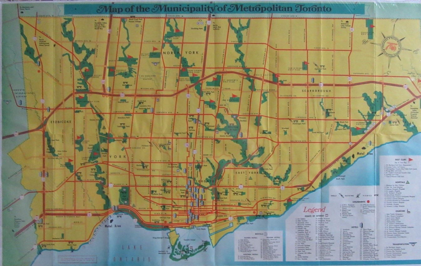
272. CONVENTION & TOURIST BUREAU OF METROPOLITAN TORONTO. Map of the Municipality of Metropolitan Toronto. 17 1/4 x 27 1/2 inches (43.8 x 69.9 cm.). colour map. Toronto: [c1960]. $100
273. COTTERELL, A.T./H.J. & W.A.BROWN. Map Of Toronto. 15 3/4 x 25 inches (40 x 63.5 cm.). lithograph. archivally matted & framed. Toronto: Willing & Williamson, 1878. $850
274. CROYDON PUBLISHING CO. Map Of Toronto And Suburbs. folding printed map. 25 7/8 x 32 7/8 inches (65.7 x 83.5 cm.). street index on verso. Toronto: [c1940]. $500
 No. 275
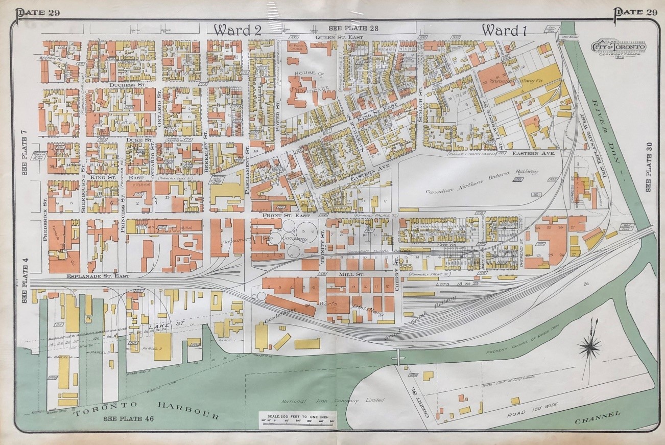
275. (DISTILLERY DISTRICT/CORKTOWN/OLD TOWN). [GOAD, Charles E.]. [Frederick St. to the Don River and Queen St. E. to the Harbour]. Plate 29 Atlas of the City of Toronto. 18 x 28 inches (45.7 x 71.1 cm.). coloured map. (light staining to lower margin & edges). Toronto: 1910. $650
Landmarks include House of Providence, Gooderham Worts Limited, and Consumers Gas Company.
276. (DOWNTOWN/OLD TOWN/ST. LAWRENCE MARKET). [GOAD, Charles E.]. [Yonge St. to Frederick St. and Richmond St. East to Front St. East]. Plate 7 Atlas of the City of Toronto. 18 x 28 inches 45.7( x 71.1cm.). coloured map. (staining to lower margin & ms. notes below the scale bar erased). Toronto: 1910. $600
Landmarks include Sheas Theatre, Post Office, W.A.Murray Co., King Edward Hotel, Albany Club, St. Lawrence Market, St. James Cathedral, and numerous banks.
 No. 277
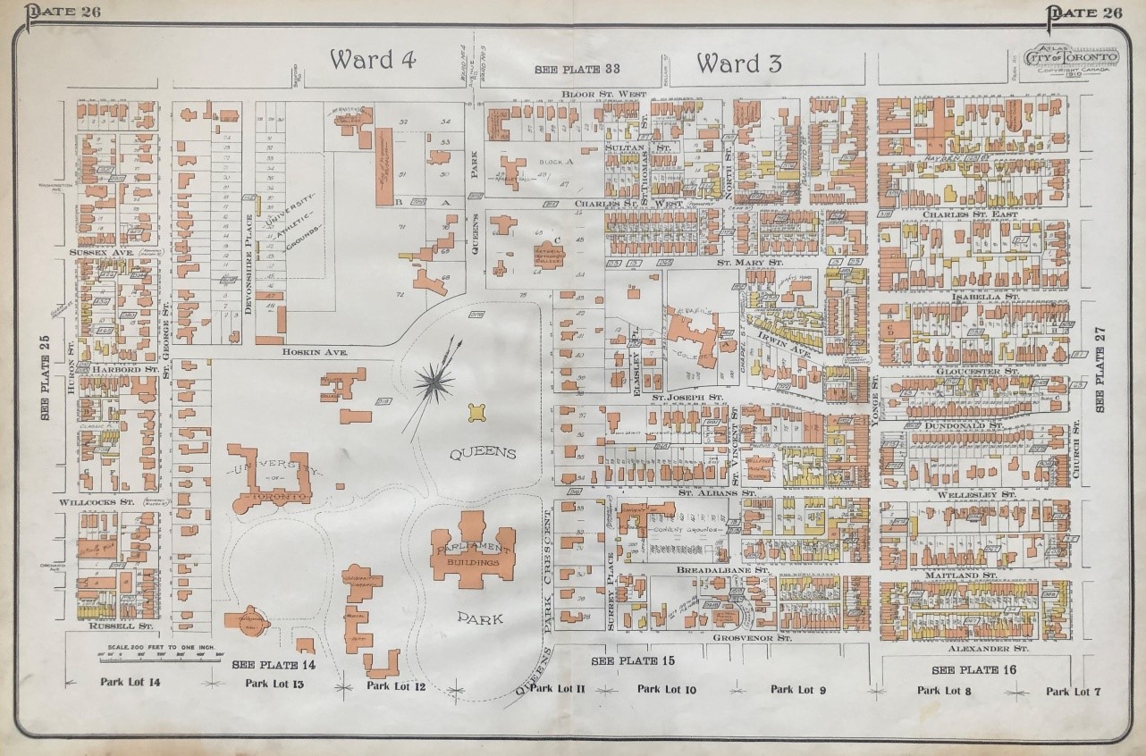
277. (DOWNTOWN/UNIVERSITY/QUEEN’S PARK/YONGE & BLOOR). [GOAD, Charles E.]. [Huron St. to Church St. and Bloor St. to Russell, Grosvenor and Alexander Sts.]. Plate 26 Atlas of the City of Toronto. 18 x 28 inches (45.7 x 71.1 cm.). coloured map. (staining in lower margin). Toronto: 1910. $500
Including the north part of the University of Toronto, Queen's Park, Victoria College, and Basil's College.
 No. 278
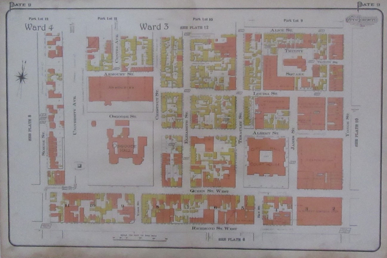
278. (DOWNTOWN/’THE WARD’). [GOAD, Charles Ed.]. [Simcoe St. to Yonge St. & Alice St. to Richmond St. West]. Plate 9 Atlas of the City of Toronto. 18 x 28 inches (45.7 x 71.1 cm.). coloured map. (some staining in lower margin). Toronto: 1910. $500
Landmarks include the Armouries, Osgoode Hall, Toronto City Hall and Court House, Trinity Square and church, T.Eaton Co. Ltd. and Robert Simpson Co. Ltd.
279. (EAST YORK). [GOAD, Charles E.]. [Pape Ave. to east of Monarch Park Ave. and McCosh Ave. to the Danforth]. Plate 112 Atlas of the City of Toronto. 18 7/8 x 27 5/8 inches (47.9 x 70.2 cm.). coloured map. Toronto: 1924. $400
 No. 280
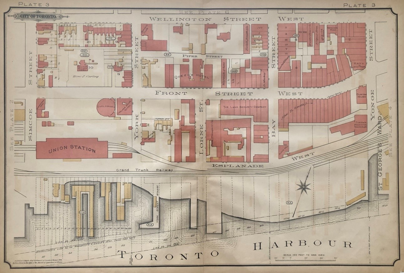
280. (FINANCIAL DISTRICT/UNION STATION). GOAD, Charles E. [Simcoe St. to Yonge St. and Wellington St. West to the Harbour]. Plate 3 Atlas of the City of Toronto. 17 ¼ x 26 ¼ inches (43.8 x 66.7 cm.). coloured map. Toronto: 1890. $350
Landmarks include Union Station, Toronto Club, Queen’s Hotel, the Land Security Company, Bank of Montreal, Union Bank, and Custom’s Examining Warehouse.
 No. 281
281. [GOAD, Charles E.]. [Dufferin St. to Pape Ave. and Woodlawn Ave, to the Harbour]. [Key Sheet Atlas of the City of Toronto]. 17 ¼ x 26 ¼ inches (43.8 x 66.7 cm.). coloured map. 1 paste-over revision. (some chipping to margins). Toronto: 1890. $700
282. GOAD, Charles E. [Spadina Avenue to Murray St. and Russell St. to Cecil St.] Plate 14 Atlas of the City of Toronto. 17 1/8 x 26 1/4 inches (43.5 x 66.7 cm.). coloured map. (slight browning, some spotting along centre fold). Toronto: 1890. $450
Showing the southern portion of the University of Toronto and the residences of John Beverley Robinson, A.M.Crosby, Frederick Perkins, Sir Daniel Wilson, Major Dawson, Henry Cawthra, &c.
283. (HARBORD VILLAGE, MIRVISH VILLAGE/PALMERSTON-LITTLE ITALY). GOAD, Charles E. [Major Square & Clinton St. to Huron St. and Bloor St. West to College St.]. Plate 25 Atlas of the City of Toronto. 17 1/8 x 26 1/4 inches (43.5 x 66.7 cm.). coloured map. (some spotting). Toronto: 1890. $450
284. (Kensington market/Chinatown/little Italy). GOAD, Charles E. [Grace St. to Spadina Ave. and College St. to Robinson and Eleanor Sts.]. Plate 23 Atlas of the City of Toronto. 17 1/8 x 26 1/4 inches (43.5 x 66.7 cm.). coloured map. (few marginal tears, some spotting & light brownng). Toronto: 1890. $500
Area includes residences of Col. Gzowski andf Mrs. J.McDonald.
Rare Plan Of Lawrence Park Estates Subdivision:
Yonge Street, Lawrence Avenue East, Bayview Avenue and Blythwood Avenue
285. (LAWRENCE PARK). DOVERCOURT LAND BUILDING & SAVINGS COMPANY LIMITED. Lawrence Park Estates And Southern Addition Strathgowan The only highly developed suburban residential property in Toronto… 19 ¼” x 24” (48.5 x 60.5 cm). colour broadside map; verso blank (few pencil & pen numbers, horizontal & vertical folds, several short holes & tears – restored & backed on rice paper by professional paper conservator). Toronto: [c1912]. $1,200
286. (LEASIDE). [GOAD, Charles E.]. [Bayview Avenue to Clark St. and Eglinton Ave. East to Millwood Rd.]. Plate 124 Atlas of the City of Toronto. 18 1/4 x 27 7/8 inches (46.4 x 70.8 cm.). partly coloured map. (some marginal soiling & marginal tear). Toronto: 1924. $350
Landmarks include Canada Wire and Cable Co., Durant Motors of Canada Ltd., and Canadian National Railway Shops.
287. LE MAY, Tracy D. (Toronto City Surveyor). Map of the City Of Toronto. Plan "C". lithographed map with partial colour. 34 1/4 X 49 inches (87 x 124.5 cm.) (sheet). lithographed by Miller Litho Co. Ltd., Toronto. (horizontal & vertical folds, occasional spotting & 1 light dampstain). Toronto: City of Toronto, [Commissioner of Works], 1929. $1,000
Large map showing existing and proposed street car streets, automobile streets, and subdivision streets.
288. (LESLIEVILLE). [GOAD, Charles E.]. [Pape St. to Woodward Ave. and Queen St. East to Ashbridge's Bay]. Plate 103 [Atlas of the City of Toronto]. 18 1/4 x 27 7/8 inches (46.4 x 70.8 cm.). partly coloured map. Toronto: 1910. $600
289. LLOYD, Frank P. F.P.Lloyd's Toronto and Suburbs.folding printed map. 20 3/8 x 32 1/4 inches (51.8 x 81.9 cm.). (tears along some folds - no loss). loosely laid in wrs. (wrs. soiled). Toronto: [c1939]. $500
290. LLOYD, Frank P. F.P.Lloyd's Toronto and Suburban Areas.printed map. 33 3/4 x 55 1/2 inches (85.7 x 141 cm.). linen-backed & attached to rollers. (browned with some stains, cracks & chipping to paper with some loss, dampstaining & chipping to right & left edges, linen backing soiled). Toronto: [c1940]. $1,200
The map extends from Toronto Island as far north as Wilson Ave. and from just west of Royal York Road in Etobicoke to Birchmount in Scarboro. Streets are named and indexed. Railway, streetcar and bus lines are shown as well as parks, schools and city and ward boundaries. On the lower left is an inset map of western Etobicoke, Long Branch and New Toronto.
 No. 291
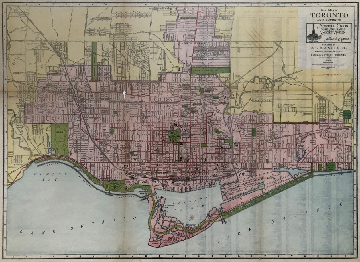
291. McAINSH, D.T. & CO. New Map of Toronto And Environs. 18 5/8 x 26 inches (47.3 x 66 cm.). printed colour map. (horizontal & vertical folds, 2 marginal holes & 1 small hole in map with slight loss). Toronto: 1914. $350
292. (McGILL STREET PLAN). Plan Of Lots the property of Jonathan Scott Esq. being part of park Lot No 8 formerly in the Township of York now in the City of Toronto. This plan is covered…under the provisions of the Registration Act…3rd Feb 1882. Signed by Jonathan Scott & Surveyor. 21 ½” x 13 ¼” (34.4 x 55 cm). folding plan on vellum (some foxing & several holes to side margin). Toronto: 1882. $300
293. (MIDTOWN/YONGE-EGLINTON). [GOAD, Charles E.]. [Cortleigh Crescent to Beulah St. east of Mount Pleasant and north of Roper St. to Eglinton Ave.]. Plate 127 Atlas of the City of Toronto. 18 x 28 inches (45.7 x 71.1 cm.). partly coloured map. (few stains in outer margins). Toronto: 1910. $400
294. MIGHT DIRECTORIES LIMITED. 1926-7. Might's Revised Single Line "Clear-View" Pocket Map In Two Colors Of Toronto and Suburbs. printed folding colour map. 27 x 35 inches (68.6 x 88.9 cm.). street index on verso. printed wrs. (tear in upper left corner & in several folds - no loss). Toronto: 1926. $700
295. MIGHT DIRECTORIES LIMITED. Might's Clearview Correct City Directory Map of Greater Toronto. printed colour map. map: 34 1/2 x 45 1/2 inches (87.6 x 116 cm.). sheet: 54 1/2 x 47 1/2 inches (138.4 x 120.7 cm.). with street index at bottom.. linen-backed & attached to rollers. with original attached pin point street finder. (some dampstaining to top & outer edges, some chipping to outer margins, some creasing & tears in top 7 inches of map with some loss), Toronto: [c1932]. $1,200
The map extends from Toronto Island as far north as Wilson Ave. and from Church St. in Etobicoke to Victoria Park Ave in Scarboro. Streets are named and indexed. Railway, streetcar and bus lines are shown as well as parks, golf courses and city and ward boundaries. There are inset maps of western Etobicoke, North York & eastern Scarboro.
296. MIGHT DIRECTORIES LIMITED. Might's Clearview Correct City Directory Map of Greater Toronto. folding printed colour map. 20 3/8 x 29 inches (51.8 x 73.7 mm). Toronto: [c1939]. $500
297. MIGHT DIRECTORIES LIMITED. Greater Toronto: Might's Official Arrow City Map. narrow 8vo. pp. 16. folding printed map.18 3/4 x 24 1/4 inches (47.6 x 61.6 cm.) (map). wrs. Toronto: [c1940]. $300
298. MIGHT DIRECTORIES LIMITED. Might's Clearview Correct City Directory Map of Greater Toronto. printed colour map. map: 34 1/4 x 45 1/8 inches (87 x 115 cm.). sheet: 40 1/2 x 53 1/2 inches (102.9 x 135.9 cm.) (sheet). with street index & inset maps of western Etobicoke, western North York & eastern Scarboro. heavier weight paper. rolled (short tear in blank portion of map, some creasing, several marginal tears, dampstains to lower margin). Toronto: [c1945]. $1,200
299. (MOORE PARK/DEER PARK/BENNINGTON/ROSEDALE). GOAD, Charles E. [Yonge St. to east of Bayview Ave. and Mount Pleasant Cemetery to Summerhill Ave]. Plate 37 Atlas of the City of Toronto. 17 1/4 x 26 1/4 inches(43.8 x 66.7 cm.). 2 paste-over cancels. partly coloured map. Toronto: 1890. $400
300. (PARKDALE PLAN). Plan Shewing Subdivision Lots 7, 8 and 9 of Reg. Plan 443 Parkdale (Dunn, Rose & Lorne Avenues).21 x 13 ¾” (53 x 35 cm). manuscript plan in black & red ink & watercolour (horizontal & vertical folds). Pencil street names corrections and additions. Signed by John Ridout, Registrar County York, January 8th, 1883, James Speight, Surveyor and O. R. Peck. Initialled note (lower right corner) March 27th, 1917. $300
301. (PARKDALE PLAN). Village Of Parkdale Plan Of Subdivision Of Lots Nos. 67 & 68 Shewn On Plan No. 333… Surveyors Certificate Sgd. Unwin, Brown & Sankey… Toronto May 1st 1883… Owners Certificate… Judges Order… 30th Day May 1883. 26 ¼” x 20” (66.4 x 50.7 cm). manuscript plan in black & red ink with horizontal & vertical folds. $300
Victoria (Empress) Crescent and Hawthorne Terrace, South Parkdale, were demolished for the Gardiner Expressway.
302. (QUEEN & SPADINA PLAN). Great Auction Sale Of ‘The Meadows’ The undersigned have pleasure in announcing that they will sell “The Meadows” property, formerly owned and occupied by the late John Hillyard Cameron…Saturday, June 29, 1978… F.W. Coate & Co., Auctioneers… 24 ½” x 18 ½”. lithographed broadside plan (margins chipped & several small holes & abrasions professionally repaired – backed on archival tissue). Toronto: 1978. $600
This broadside advertises the sale of lots on a new street, “Cameron St.”, at Queen Street and Spadina Avenue. “The Meadows” property was formerly owned by the politician, lawyer and politician, John Hillyard Cameron (1817-1876).
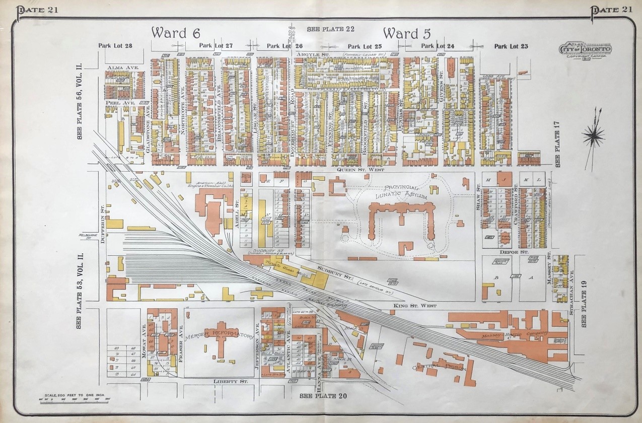 No. 303
303. (QUEEN ST. WEST/LIBERTY VILLAGE). [GOAD, Charles E.]. [Dufferin St. to Strachan Ave. and Argyle St. to Liberty St.]. Plate 21 Atlas of the City of Toronto. 18 x 28 inches (45.7 x 71.1 cm.). coloured map. Toronto: 1910. $500
Landmarks include Mercer Reformatory, the Provincial Lunatic Asylum, Massey-Harris Company, and Central Prison.
304. RENOUF, S.A., ADVERTISING COMPANY. Map Of Toronto Metropolitan Area Including the 12 Adjoining Municipalities. folding printed map. 25 7/8 x 42 inches (65.7 x 106.7 cm.). street index on verso. (some tears along folds - no loss, some soiling to title section). Toronto: [c1950]. $500
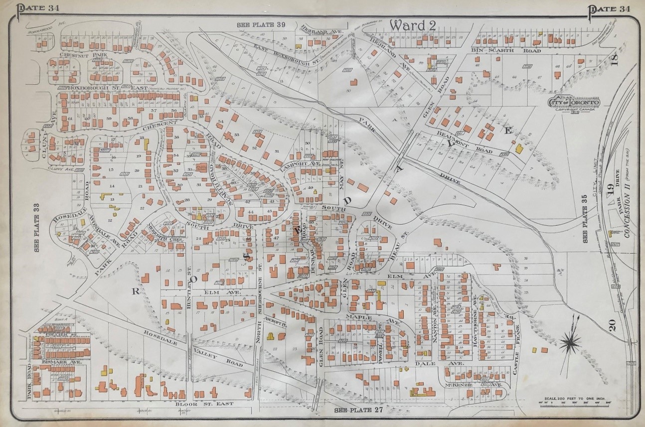 No. 305
305. (ROSEDALE). [GOAD, Charles Ed.]. [Rosedale Road & Cluny Drive to Castle Frank and Highland Ave. to Bloor St. East]. Plate 34 Atlas of the City of Toronto. 18 x 28 inches (45.7 x 71.1 cm.). coloured map. (staining to lower margin). Toronto: 1910. $800
306. (SCARBOROUGH. BELLAMY ROAD). Plan Of Part Of The Bellamy Land Cos. Estate, Scarboro. Head Office 36 King St. East Toronto, Branch Office Bellamy Station.Verso: Map Of Toronto Situating The Bellamy Estate. 28” x 17” (entire sheet; 71 x 43.2 cm). horizontal & vertical folds (several stains to upper right corner & lower left margin, some creasing & tears to folds with 1 cm loss). Toronto: [c1900]. $500
The Bellamy Land Cos. Estate’s plan for this Scarborough subdivision (Kingston Road to Lake Ontario and Secor Avenue to Frances Drive) shows 45 lots and 80 feet reserved for beach promenade.
307. T. EATON CO. LIMITED. colour map of Toronto.17 1/4 x 31 1/2 inches (43.8 x 80 cm.).. Toronto: [c1960's-70's]. $100
308. TACKABURY, George N. (Publisher). Toronto. [Atlas of the Dominion of Canada].14 1/2 x 23 1/4 (43.8 x 59.1 cm.). colour lithographed map. archivally matted & framed. Montreal: 1875. $1,000
309. TORONTO. CITY ENGINEER'S OFFICE. Plan Of The City Of Toronto. folding partly hand-coloured lithographed map. linen-backed. 21 1/2 x 37 inches (54.6 x 94 cm.). lithographed by Copp Clark, Co. Ltd. (lower edge cropped with some loss to Toronto Islands, trimmed to neat line on left, numerous small holes & chips with some loss). dated in ms. on verso. Toronto: [1893]. $700
310. TORONTO TRANSPORTION COMMISSION. Route Map: Street Car and Bus Services in Toronto and Adjoining Municipalities. 12 1/2 x 17 1/8 inches (31.75 x 43.5 cm.). folded as a brochure, with TTC fare & other information on verso. Toronto: [c1921]. $75
311. TORONTO TRANSPORTION COMMISSION. Toronto Visitors' Guide. folding printed colour map. map: 18 x 23 3/8 inches (45.7 x 59.4 cm.). sheet: 18 3/8 x 32 3/8 inches (46.7 x 82.2 cm.). street index. detailed TTC route maps on verso. folded as a brochure with front colour cover panel, TTC information & detailed route maps on verso. Toronto: [c1940]. $150
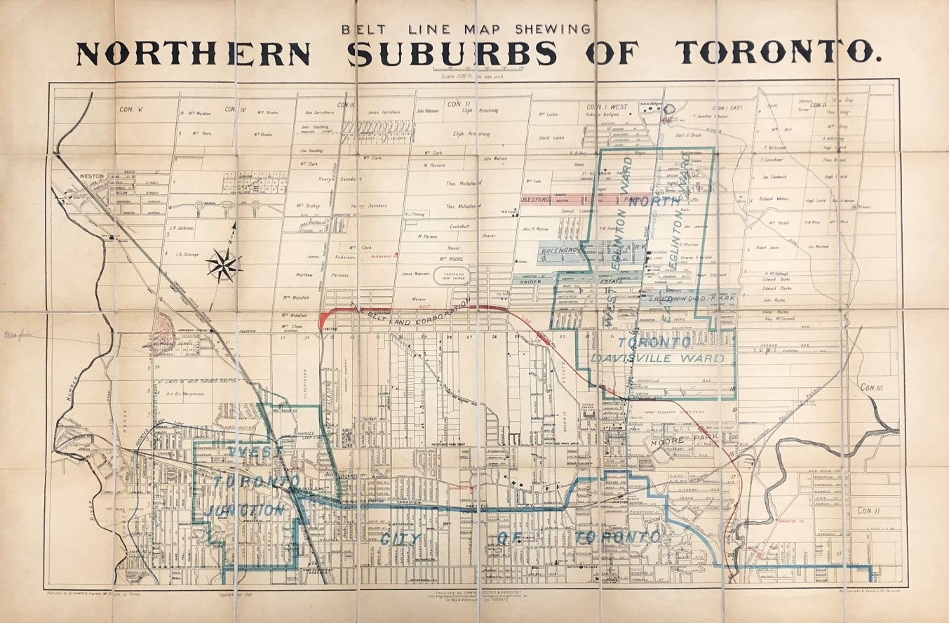 No. 312
312. UNWIN, FOSTER & PROUDFOOT. Belt Line Map Shewing Northern Suburbs Of Toronto. folding lithographed map with partial colour. lithographed by Alexander & Cable. map: 19 3/8 x 32 3/8 inches (49.2 x 82.2 cm.). sheet: 24 1/8 x 36 5/8 inches (61.3 x 93 cm.). sectioned & backed on linen. folded into original cloth binding (spine damaged, some browning). Toronto: B.Sawden, 1890. $1,500
A booming real estate market in the late 1880s led to the foundation of two related companies. The Toronto Belt Land Corporation was incorporated on July 16, 1889 to subdivide and sell land in the new suburbs, and the Toronto Belt Line Railway Company was founded on March 23, 1889 to build a commuter railway to connect these new suburban areas to the city. The Belt Line Railway, shown in red on the map, consisted of two separate loops, both starting from Union Station. The eastern loop circled around the north end of the city via the Don Valley, Mount Pleasant Cemetery and the Grand Trunk Railway tracks in the west, while the western loop passed through Swansea, Lambton and West Toronto Junction, returning to Union Station, via Parkdale.A lack of sufficient development led to the closure of service on the railway on November 17, 1894, after just 27 months, Part of the line is now used as a park (Kay Gardner Beltline Park). The present map includes names of landowners.
313. (YONGE & DAVISVILLE). Plans of the Subdivision of Lot No 17 in the 3rd Conc[ession] from the Bay Township of York in the County of York and Province of Ontario… No 306. signed by H[enry James] Grasett, “Owner Rector of St. James Church Toronto”, initialled by“R.L. Surveyor” Oct. 8th, 1870 and John Ridout, Jany. 24th, 1871. manuscript plan in black ink. horizontal & vertical folds (few small holes at folds, left edge creased with short tear & two stains, remnants of two mounts to verso edges). $300
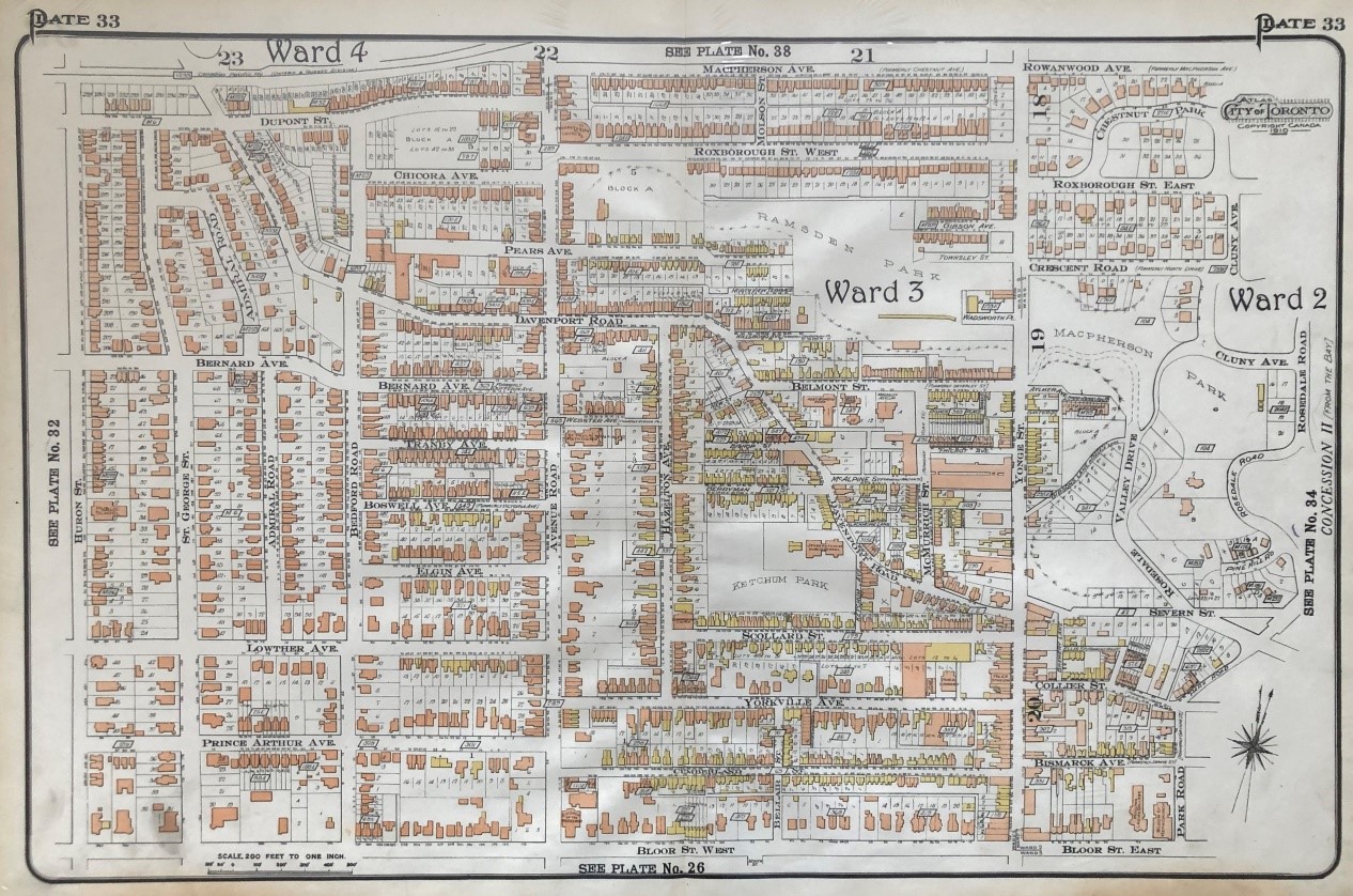 No. 314
314. (YORKVILLE/ANNEX/SUMMERHILL/ROSEDALE). [GOAD, Charles E.]. [Huron St. to Rosedale Valley Road and Macpherson to Bloor St. West]. Plate 33 Atlas of the City of Toronto. 18 x 28 inches (45.7 x 71.1 cm.). colour map. (staining to lower margin, one inside the plate). Toronto: 1910. $750
Landmarks include Jessie Ketchum Public School and park, Ramsden Park, Bloor St. Methodist Church, Moulton Ladies College, and Church of the Redeemer.